Operational Oceanography
What Is Operational Oceanography?
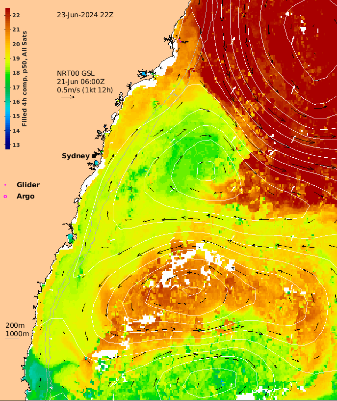
Operational Oceanography is like weather monitoring and forecasting for the ocean. It can provide estimates of essential ocean variables (e.g. sea level, temperature and currents) for the present and the future, as well as for the past.
Operational Oceanography can be used to improve safety of life at sea, help create wealth, and assist in the security and protection of the marine environment.
Outputs can be used to generate data products, applications and services through national authorities, as well as in some cases through other organisations such as metocean service providers and environmental consultants.


“Operational Oceanography can be defined as the activity of systematic and long-term routine measurements of the seas and oceans and atmosphere, and their rapid interpretation and dissemination”
European component of the Global Ocean Observing System (EuroGOOS)
Operational Oceanography Applications

Warnings about coastal floods, storm impacts, harmful algal blooms and contaminants.

Electronic charts, sea state conditions, optimum routes for ships.

Prediction of primary productivity, ocean currents, ocean climate variability.

Modelling of, and in response to, oil spills and dredging.
Forecasts, Nowcasts & Hindcasts
Present estimates are called Nowcasts and provide descriptions of the present state of the ocean.
Future estimates called Forecasts are updated regularly, typically for one to two weeks ahead.
Reanalyses and hindcasts can also be produced to provide descriptions of past states, and time series showing trends and changes. Hindcasts are typically the “best” estimates having the greatest number of observations and the best available quality control.
Observations & Models
Operational Oceanography depends on availability of ocean observations and super-computer facilities, and uses computer models and mathematical techniques that have been developed over several decades.
It is designed to deliver stakeholder defined outputs and products on a routine basis, using robust and fully supported production and dissemination techniques.


Ocean observations are required in real-time and near-real-time (within a few days or minutes of collection) and sourced from various national and international programs.
Some of these services are run in an operational setting, for example the World Meteorological Organisation or the Intergovernmental Oceanographic Commission.
Others are maintained through research funding, for example Australia’s Integrated Marine Observing System.
Operational Oceanography Systems In Australia
Most Operational Oceanography systems are run at national weather centres, for example the Bureau of Meteorology. These systems often depend on coordinated efforts from multiple organisations,
Australia’s operational ocean forecast system, operated at the Bureau of Meteorology has been developed under a partnership called BLUElink.
BLUElink is a partnership between the Bureau of Meteorology, CSIRO, and the Royal Australian Navy.
Operational Oceanography Programs In Australia
Operational oceanographic programs are well established in countries such as USA, Japan and France. In Australia, a number of products and services are well established while others are developing. The examples below are observational and operational products and services developed by Australian institutions.

